Log in
All resources
Create a design
Tools
7,171 Free Images of Atlas Map
joan blaeu
copper engraving print
british library
beschreibung und contrafactur der vornembster stät der welt, liber primus civitates orbis terrarum
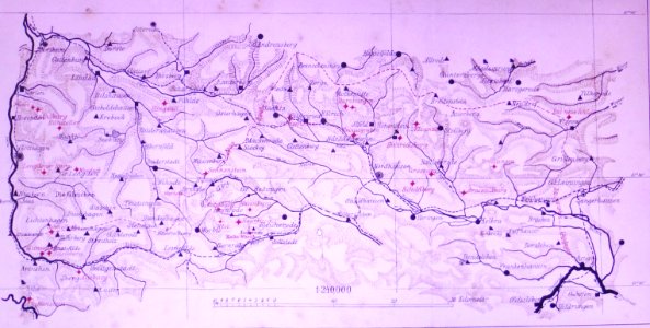
atlas maior, vol 3 (germany) - joan blaeu, 1667 - bl 114.h(star).3
atlas van loon
atlas sive cosmographicae (gerardus mercator, 1623)
atlas novus (blaeu)
gemeente atlas van nederland - north brabant
bibliothèque nationale de france
atlas maior, vol 1 (northern europe, norway, and denmark) - joan blaeu, 1667 - bl 114.h(star).1
copper engraving print
atlas maior, vol 3 (germany) - joan blaeu, 1667 - bl 114.h(star).3
copper engraving print
atlas maior, vol 2 (sweden, russia, poland, eastern europe, and greece) - joan blaeu, 1667 - bl 114.h(star).2
copper engraving print
map of the german empire by louis stanislas d'arcy de la rochette
1782 maps of the holy roman empire
18th-century maps of the indian ocean
18th-century maps of southeast asia
nieuwe en beknopte hand-atlas (1754)
wüstung äppelhausen
schlattingen
atlas maior, vol 3 (germany) - joan blaeu, 1667 - bl 114.h(star).3
copper engraving print
atlas maior, vol 2 (sweden, russia, poland, eastern europe, and greece) - joan blaeu, 1667 - bl 114.h(star).2
copper engraving print
atlas maior, vol 3 (germany) - joan blaeu, 1667 - bl 114.h(star).3
copper engraving print
atlas maior, vol 2 (sweden, russia, poland, eastern europe, and greece) - joan blaeu, 1667 - bl 114.h(star).2
copper engraving print
atlas maior, vol 3 (germany) - joan blaeu, 1667 - bl 114.h(star).3
copper engraving print
atlas maior, vol 3 (germany) - joan blaeu, 1667 - bl 114.h(star).3
copper engraving print
siege of jülich 1610
atlas van loon
old maps of the russian empire
1790s maps of alaska
maps of hardenberg
avereest
nieuwe en beknopte hand-atlas (1754)
atlas géographique des quatre parties du monde (delisle)
18th-century maps of the iberian peninsula
atlas maior, vol 3 (germany) - joan blaeu, 1667 - bl 114.h(star).3
copper engraving print
atlas maior, vol 3 (germany) - joan blaeu, 1667 - bl 114.h(star).3
copper engraving print
atlas maior, vol 3 (germany) - joan blaeu, 1667 - bl 114.h(star).3
copper engraving print
atlas maior, vol 3 (germany) - joan blaeu, 1667 - bl 114.h(star).3
copper engraving print
atlas maior, vol 3 (germany) - joan blaeu, 1667 - bl 114.h(star).3
copper engraving print
atlas maior, vol 3 (germany) - joan blaeu, 1667 - bl 114.h(star).3
copper engraving print
atlas maior, vol 1 (northern europe, norway, and denmark) - joan blaeu, 1667 - bl 114.h(star).1
copper engraving print
a & c black general atlas of the world
1850s maps of the world
maps of assen
paterswolde
maps by gerardus mercator
kempen (region)
1594 in aschaffenburg
1594 maps of bavaria
media from regionaal archief alkmaar
zijpe
atlas minor gerardi mercatoris (1621, maps)
maps of liège by baptista van doetecum
lion of guelders in heraldry
coats of arms of groenlo
beschreibung und contrafactur der vornembster stät der welt, liber primus civitates orbis terrarum
maps of wesel by braun & hogenberg
beschreibung und contrafactur der vornembster stät der welt, liber primus civitates orbis terrarum
maps of lindau (bodensee) by braun & hogenberg
beschreibung und contrafactur der vornembster stät der welt, liber primus civitates orbis terrarum
maps of safi by braun & hogenberg
beschreibung und contrafactur der vornembster stät der welt, liber primus civitates orbis terrarum
maps of weimar by braun & hogenberg
beschreibung und contrafactur der vornembster stät der welt, liber primus civitates orbis terrarum
maps of 's-hertogenbosch by braun & hogenberg
beschreibung und contrafactur der vornembster stät der welt, liber primus civitates orbis terrarum
maps of kozhikode by braun & hogenberg
beschreibung und contrafactur der vornembster stät der welt, liber primus civitates orbis terrarum
maps of málaga by braun & hogenberg
maps by pieter mortier
le neptune francois
maps from university of amsterdam special collections
atlas der neederlanden
maps from university of amsterdam special collections
atlas der neederlanden
maps by pieter mortier
le neptune francois
breda, netherlands in the 17th century
old maps of north brabant
beschreibung und contrafactur der vornembster stät der welt, liber primus civitates orbis terrarum
maps of azemmour by braun & hogenberg
beschreibung und contrafactur der vornembster stät der welt, liber primus civitates orbis terrarum
maps of osnabrück by braun & hogenberg
beschreibung und contrafactur der vornembster stät der welt, liber primus civitates orbis terrarum
maps of nördlingen by braun & hogenberg
beschreibung und contrafactur der vornembster stät der welt, liber primus civitates orbis terrarum
maps of aden by braun & hogenberg
beschreibung und contrafactur der vornembster stät der welt, liber primus civitates orbis terrarum
maps of 's-hertogenbosch by braun & hogenberg
beschreibung und contrafactur der vornembster stät der welt, liber primus civitates orbis terrarum
maps of stade by braun & hogenberg
beschreibung und contrafactur der vornembster stät der welt, liber primus civitates orbis terrarum
maps of siena by braun & hogenberg
beschreibung und contrafactur der vornembster stät der welt, liber primus civitates orbis terrarum
maps of heidelberg by braun & hogenberg
catalan atlas
mansa musa
maps of fossa eugeniana by willem and johannes blaeu
atlas novus (blaeu)
maps of fossa eugeniana by willem and johannes blaeu
atlas novus (blaeu)
maps of fossa eugeniana by willem and johannes blaeu
atlas novus (blaeu)
maps from university of amsterdam special collections
atlas der neederlanden
atlas ou representation du monde universel t. 2 (1633)
nicolaes visscher i
maps in the library of congress
old maps of new jersey
maps from university of amsterdam special collections
atlas der neederlanden
18th-century maps of korea
nouvel atlas de la chine
media from regionaal archief alkmaar
broek op langedijk
gemeente atlas van nederland - north brabant
dieden
atlas vingboons
1665
map of the german empire by louis stanislas d'arcy de la rochette
1780s maps of lithuania
siege of schenkenschans 1636
atlas van loon
historisk atlas (stockholm, norstedt & söner, 1880)
maps of 11th-century italy
maps by pieter mortier
le neptune francois
old maps of enkhuizen
atlas van loon
old maps of grave, netherlands
atlas van loon
history of waldeck (am edersee)
coats of arms of waldeck family
historical
history
panda
maps
maps by john cary
1799 maps
historical
history
old maps of southeast asia
maps by gerard valck
gemeente atlas van nederland - north brabant
drongelen
gemeente atlas van nederland - north brabant
oerle
gemeente atlas van nederland - south holland
maps of geervliet
maps of anglesey and channel islands by gerardus mercator
atlas sive cosmographicae (gerardus mercator, 1623)
maps of alsace, breisgau and sundgau by gerardus mercator
atlas sive cosmographicae (gerardus mercator, 1623)
atlas sive cosmographicae (gerardus mercator, 1623)
maps of provence by pierre-jean de bompar
gemeente atlas van nederland - north brabant
maps of cuijk
gemeente atlas van nederland - north brabant
maps of sint-michielsgestel
maps of cornwall and south wales by gerardus mercator
atlas sive cosmographicae (gerardus mercator, 1623)
atlas sive cosmographicae (gerardus mercator, 1623)
maps of east flanders by pieter van der keere
old maps of spitsbergen
1642
old maps of arnhem
rhine in arnhem
1800s maps of denmark
1801 maps of europe
cartouches by willem and johannes blaeu
joan blaeu
atlas sive cosmographicae (gerardus mercator, 1623)
maps of île-de-france by françois de la guillotière
atlas sive cosmographicae (gerardus mercator, 1623)
maps of ireland facing west by gerardus mercator
maps of zürichgau and basel province by gerardus mercator
atlas sive cosmographicae (gerardus mercator, 1623)
17th-century maps of maastricht
siege of maastricht (1632)
maps of heusden, north brabant
atlas van loon
history of alphen aan den rijn
maps of aarlanderveen
atlas ou representation du monde universel t. 1 (1633)
maps by hendrik hondius the younger
gemeente atlas van nederland - drenthe
maps of de wolden
siege of sluis 1604
old maps of sluis
atlas ou representation du monde universel t. 1 (1633)
maps by hendrik hondius the younger
3401 - 3500 of 7,171
Next page
/ 72


![Beschreibung und Contrafactur der Vornembster stät der Welt, liber primus [Civities of the World], 1574](https://cdn.creazilla.com/illustrations/10001053923/beschreibung-und-contrafactur-der-vornembster-stt-der-welt-liber-primus-civities-of-the-world-1574-sm.webp)
![Beschreibung und Contrafactur der Vornembster stät der Welt, liber primus [Civities of the World], 1574](https://cdn.creazilla.com/illustrations/10001029745/beschreibung-und-contrafactur-der-vornembster-stt-der-welt-liber-primus-civities-of-the-world-1574-sm.webp)
![Beschreibung und Contrafactur der Vornembster stät der Welt, liber primus [Civities of the World], 1574](https://cdn.creazilla.com/illustrations/10001083337/beschreibung-und-contrafactur-der-vornembster-stt-der-welt-liber-primus-civities-of-the-world-1574-sm.webp)
![Beschreibung und Contrafactur der Vornembster stät der Welt, liber primus [Civities of the World], 1574](https://cdn.creazilla.com/illustrations/10001324188/beschreibung-und-contrafactur-der-vornembster-st-t-der-welt-liber-primus-civities-of-the-world-1574-sm.jpg)
![Beschreibung und Contrafactur der Vornembster stät der Welt, liber primus [Civities of the World], 1574](https://cdn.creazilla.com/illustrations/10000649256/beschreibung-und-contrafactur-der-vornembster-st-t-der-welt-liber-primus-civities-of-the-world-1574-sm.jpg)
![Beschreibung und Contrafactur der Vornembster stät der Welt, liber primus [Civities of the World], 1574](https://cdn.creazilla.com/illustrations/10001037322/beschreibung-und-contrafactur-der-vornembster-stt-der-welt-liber-primus-civities-of-the-world-1574-sm.webp)
![Beschreibung und Contrafactur der Vornembster stät der Welt, liber primus [Civities of the World], 1574](https://cdn.creazilla.com/illustrations/10000408860/beschreibung-und-contrafactur-der-vornembster-stt-der-welt-liber-primus-civities-of-the-world-1574-sm.webp)

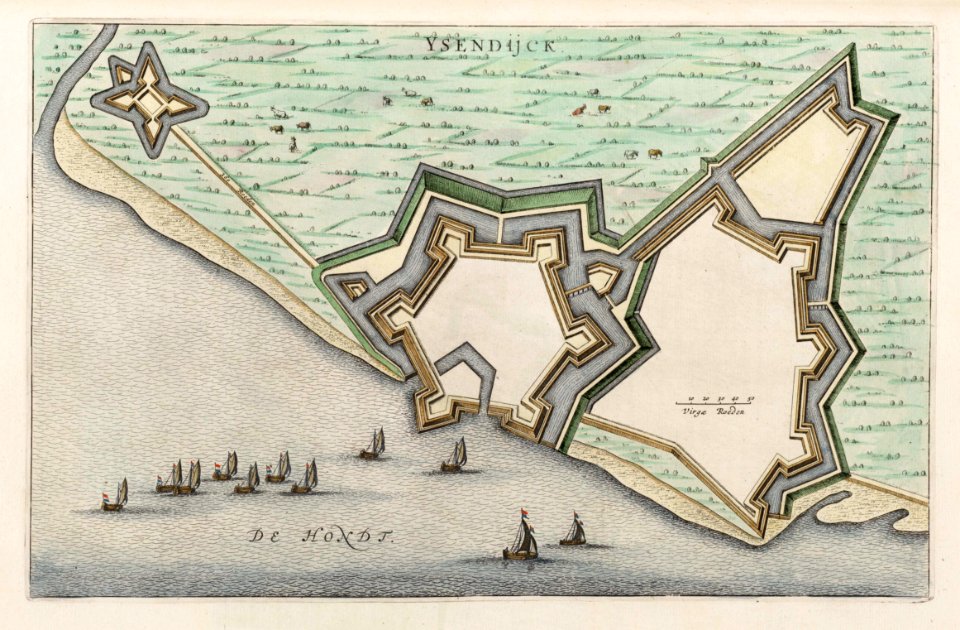
![Caarte van Ste. Anna Polder ende ’t Schape Gors / H. vander Dyck fecit; A. Steyaart invenit; I. Stemmers sculpsit; I. Luiken fecit cum aqua forti, Romeyn de Hooghe, [1701]](https://cdn.creazilla.com/illustrations/10000526879/caarte-van-ste-anna-polder-ende-t-schape-gors-h-vander-dyck-fecit-a-steyaart-invenit-i-stemmers-sculpsit-i-luiken-fecit-cum-aqua-forti-romeyn-de-hooghe-1701-md.jpg)
![Caarte van Sinte Cornelis Polder anders De Quacq / A. Steyaart invenit; I. Stemmers sculpsit; I. Luiken fecit cum aqua forti, Romeyn de Hooghe, [1701]](https://cdn.creazilla.com/illustrations/10000517198/caarte-van-sinte-cornelis-polder-anders-de-quacq-a-steyaart-invenit-i-stemmers-sculpsit-i-luiken-fecit-cum-aqua-forti-romeyn-de-hooghe-1701-md.jpg)


![Beschreibung und Contrafactur der Vornembster stät der Welt, liber primus [Civities of the World], 1574](https://cdn.creazilla.com/illustrations/10000539145/beschreibung-und-contrafactur-der-vornembster-st-t-der-welt-liber-primus-civities-of-the-world-1574-sm.jpg)
![Beschreibung und Contrafactur der Vornembster stät der Welt, liber primus [Civities of the World], 1574](https://cdn.creazilla.com/illustrations/10000615628/beschreibung-und-contrafactur-der-vornembster-stt-der-welt-liber-primus-civities-of-the-world-1574-sm.webp)
![Beschreibung und Contrafactur der Vornembster stät der Welt, liber primus [Civities of the World], 1574](https://cdn.creazilla.com/illustrations/10000869579/beschreibung-und-contrafactur-der-vornembster-st-t-der-welt-liber-primus-civities-of-the-world-1574-sm.jpg)
![Beschreibung und Contrafactur der Vornembster stät der Welt, liber primus [Civities of the World], 1574](https://cdn.creazilla.com/illustrations/10001083437/beschreibung-und-contrafactur-der-vornembster-stt-der-welt-liber-primus-civities-of-the-world-1574-sm.webp)
![Beschreibung und Contrafactur der Vornembster stät der Welt, liber primus [Civities of the World], 1574](https://cdn.creazilla.com/illustrations/10001057342/beschreibung-und-contrafactur-der-vornembster-st-t-der-welt-liber-primus-civities-of-the-world-1574-sm.jpg)
![Beschreibung und Contrafactur der Vornembster stät der Welt, liber primus [Civities of the World], 1574](https://cdn.creazilla.com/illustrations/10000384878/beschreibung-und-contrafactur-der-vornembster-st-t-der-welt-liber-primus-civities-of-the-world-1574-sm.jpg)
![Beschreibung und Contrafactur der Vornembster stät der Welt, liber primus [Civities of the World], 1574](https://cdn.creazilla.com/illustrations/10000237213/beschreibung-und-contrafactur-der-vornembster-stt-der-welt-liber-primus-civities-of-the-world-1574-sm.webp)
![Beschreibung und Contrafactur der Vornembster stät der Welt, liber primus [Civities of the World], 1574](https://cdn.creazilla.com/illustrations/10001520412/beschreibung-und-contrafactur-der-vornembster-st-t-der-welt-liber-primus-civities-of-the-world-1574-sm.jpg)


![Gerardi Mercatoris and I. Hondii Atlas or Representation of the Universal World, and of the Parts of It, Made in Tables and Very Ample Descriptions. [t. 2]., Nicolaes Visscher](https://cdn.creazilla.com/illustrations/10000298847/gerardi-mercatoris-and-i-hondii-atlas-or-representation-of-the-universal-world-and-of-the-parts-of-it-made-in-tables-and-very-ample-descriptions-t-2-nicolaes-visscher-sm.webp)

![Map of the Newly Remodeled Sea Dyke - Dutch Coastal Defenses, Hendrik de Leth, [1737]](https://cdn.creazilla.com/illustrations/10000604534/map-of-the-newly-remodeled-sea-dyke-dutch-coastal-defenses-hendrik-de-leth-1737-sm.webp)


![Gerardi Mercatoris and I. Hondii Atlas or Representation of the Universal World, and of the Parts of It, Made in Tables and Descriptions Very Ample, and Exact: Divided into Two Volumes [...]. [t. 1].](https://cdn.creazilla.com/illustrations/10001462413/gerardi-mercatoris-and-i-hondii-atlas-or-representation-of-the-universal-world-and-of-the-parts-of-it-made-in-tables-and-descriptions-very-ample-and-exact-divided-into-two-volumes-t-1-md.jpg)


![Gerardi Mercatoris and I. Hondii Atlas or Representation of the Universal World, and of the Parts of It, Made in Tables and Descriptions Very Ample, and Exact: Divided into Two Volumes [...]. [t. 1].](https://cdn.creazilla.com/illustrations/10000604152/gerardi-mercatoris-and-i-hondii-atlas-or-representation-of-the-universal-world-and-of-the-parts-of-it-made-in-tables-and-descriptions-very-ample-and-exact-divided-into-two-volumes-t-1-sm.webp)